Uyuni, Bolivia

That night we reboarded another bus to Uyuni, where the Dakar Rally was happening.

IMG_9464IMG_9385
Dakar is the biggest rally in the world, and it was called the Paris-Dakar. On Those early years it ran from France to Senegal, North Africa, crossing many countries in the Sahara desert, but because terrorist treats and political Instabilities, it changed name and moved to South America, where it crosses the deserts of Argentina, Chile and Bolivia . It has trucks, cars, quad racers and motorcycles, and the next day, the cars, quad racers and motorcycles would arrive in the city, and we wanted to be there to witness this huge event with the presence of the Bolivian government top personnel and the president him self, Mr Evo Morales.

UYUNI

The bus trip from Sucre redbourn about 7 hours and we arrived on the dusty streets of Uyuni at 3:30 AM, not a good time at all!
We got of the bus and Were shocked to find the city – village like- full of drunk young men who cam for the weekend dakar parties. It was scary, and I was totally uncomfortable with Ericka next to me.

IMG_9467IMG_9468

We had no clue where our hotel was, wandered to the dirty streets where lots of people were sleeping in tents, right on the sidewalks, or sleeping on benches all over town. We tried to ask for information, but majority of people Were totally wasted! Finally I found our hotel and after a little confusion, They let us in and wait for the check in time in the morning.

IMG_9470IMG_9483IMG_9477IMG_9473IMG_9472

We stayed in the waiting room, and from there we Could see through the window, how chaotic the situation was on the streets. The sun soon cam and things went back to normal for the drunks dispersed and vendor Began setting up Their tents with tons of things to be sold to tourists from all over.

We slept for about one or two hours on the lobby in the hotel room until They finally gave us a room because of the check in time. We redbourn the shower and left to see the arrival of the motorcycles and quad racers on the main boulevard, where a huge crowd had accumulated since early hours. Evo Morales was there too. It was very hard to find a place to see the bikes, but for some unknown reason, we found ourselves in the middle of the street right on the arrival spot. We had DSLR cameras and the Bolivians probably thought we Were journalists, and we exploited the situation by posing Actually the ones. LOL!

IMG_9503IMG_9635IMG_9629IMG_9627IMG_9545IMG_9533

From our position, we Could Not only see the top competitors arriving, but interview Them if we wanted. It was a jack pot!

The weather was not good and rain started coming down, sometimes hard, and after couple hours we DECIDED to bail out and see the whole thing live on a TV set inside the restaurant one block away.

I watched the live transmission drinking a few beers and trying to warm up a little, and in the team we met some Brazilian girls and the dutch couple who Were Also traveling pretty much the same route the ours. We had a nice chat all afternoon and got ready for the night in town.

IMG_9662

IMG_9659

At night the town was vibrant with a center stage where Several musicians played until early hours of the next day. There Were people from everywhere!

IMG_9669IMG_9671IMG_9670

The next morning we booked the 4 day journey on the Toyota 4Runner to visit the famous Salar de Uyuni, the biggest salt desert in the world, where we would cross the desert and arrive in Chile.

IMG_9678IMG_9718IMG_9714IMG_9707IMG_9701IMG_9699IMG_9695IMG_9694IMG_9692
IMG_9683IMG_9722

Salar de Uyuni

This is the largest salt flat in the world at 10.582 square kilometers, and it is located in Potosi, Bolivia Southwest. It is the results of transformation between Several prehistoric lakes.
It contains the 50 to 70% of the worlds lithium reserves and it is a wonderful place to visit. The photos say by Themselves.

DSC_0129DSC_0267DSC_0260DSC_0247DSC_0245DSC_0244
DSC_0239DSC_0237DSC_0232DSC_0149DSC_0145DSC_0143DSC_0142
DSC_0137

That night we slept on a hostel made of salt blocks in the middle of the desert with a large group of this tour. Our Landrover had six people plus the driver, there Were two very nice girls from Argentina, Lorela and Eliane, and a brother and sister from Spain, Alba and Josep, and Ericka and myself.

DSC_0273
DSC_0185DSC_0183
DSC_0176DSC_0168DSC_0166DSC_0164DSC_0160DSC_0158DSC_0154DSC_0295DSC_0294DSC_0293DSC_0291DSC_0281DSC_0278DSC_0275DSC_0211DSC_0231DSC_0230DSC_0229DSC_0223
DSC_0221

DSC_0224DSC_0228DSC_0220DSC_0215
We made good friendships and really enjoyed These four days, except for the comically horrible food served at all of the desert hostels.

DSC_0193DSC_0206DSC_0205DSC_0200DSC_0197DSC_0194

The hostel looks good at the first glance, but the restrooms Were filthy dirty clogged all the way to the top! It is totally disgusting, but we had no other choice whatsoever. Showers Were hot and we slept with 10 people in one room.
Bathrooms did not have toilet seats, toilet paper or locks on the door. It was not pleasant Actually.

Tihuanaco and Puma Punko

TIHUANACO AND PUMA PUNKO
45 miles later, we arrived at Puma Punku, mysterious ancient ruins spread across the Andes mountain desert plateau at 13,000 feet.
IMG_9100

DCIM100GOPROGOPR0713.

As soon as we arrived, we began to explore the ruins. It was incredible to feel the energy of this place. After a couple minutes, we were astonished by the most strange and unbelievable rainbow we have ever seen.
 IMG_9015
The prismatic colors stood out so vibrantly in the sky, and it was unlike anything. We stood in amazement and observed the magical sight, snapping a few pictures.
 IMG_9016
The blocks here aren’t found anywhere else on the entire planet. It’s a place where logic just doesn’t make sense.
This place is believed to have been constructed with the alignment of the stars. The intricate designs and precise cuts on each stone provides evidence that there was clearly something else at work, if these primitive beings didn’t have power tools.
IMG_9129
IMG_9124
IMG_9123
IMG_9103
IMG_9104
IMG_9122
IMG_9119
IMG_9121
IMG_9126
IMG_9102
 IMG_9154IMG_9133
These infamous H blocks are made of solid andesite and are precisely interlocked. Everything here is utterly perfect yet so incredibly mysterious.IMG_9106
IMG_9109IMG_9107
IMG_9112
IMG_9134
There is a rock here that distorts compasses, demonstrating that it has clearly been magnetized. The true question is: has it exposed to electromagnetic waves, or did it undergo something strange?
 IMG_9095
Keeping in mind that this place is so high in the mountains and so distant from anything, it’s hard believe it was anything other than influenced by something alien.
IMG_9097

Next to Puma Punku lies, Tihuanaco, a precolumbian archaeological site. The structures found here were discovered in 1549 by a explorer Pedro Cieza de León, while searching for the Inca capital of Qullasuyu.

DSC_1121

It’s a sort of spiritual and political center, dating back to 3,000 BC.
IMG_9003IMG_9080
IMG_9121IMG_9122IMG_9025IMG_9087IMG_9014IMG_9021IMG_8995
The structures here include the gateway of sun, an elaborate calendar that contradicts our evolution, a 21ft ancient monolith, and a stone wall that represents every diverse person, culture, and face.
 IMG_9020IMG_9025

DCIM100GOPROGOPR0687.

IMG_9050IMG_9049IMG_9043

The faces surrounding this wall feature some otherworldly looking alien heads, and other mysterious faces with elongated skulls.
 IMG_9055IMG_9034
We were extremely impressed with these enigmatic ruins that have been studied as a site with extraterrestrial elements.
The energy of Tihuanaco and Puma Punku is incredibly peaceful and alive. There is an element of magic and mystery that is so different from the rainy gloom found just hours before in La Paz.
 DSC_0009DSC_0013
From La Paz we took a bus 15 hours south bound to city of Sucre, also known as The White City, where we would continue on this journey through South America.

La Paz, Bolivia

LA PAZ – BOLIVIA
We came in city with chaos. There was a huge protest against the government and the city was shut down, preventing all transportation from getting past the protesters. We had to walk for 2 hours in the crowed streets with heavy backpacks until we cross the epicenter of the protesters to try to get a cab to our hostel.
IMG_8924IMG_8921
IMG_8927IMG_8920
Our hostel was actually a very nice and cozy bed & breakfast with great hospitality. We looked for a good restaurant that night, just to compensate the suffering on these long journey. We found a fancy French restaurant called Chez Moustache, and indulged in the best dinner we’ve had yet!
 IMG_8945
We had 4 glasses of Bourdeaux wine, 2 bottles of Perrier water, steak with Roquefort sauce and patties, and a beautiful salmon plate. The entire candlelit dinner experience was topped off with fine waiters. To our surprise, the final price was only $46 dollars! Amazing! It we had the same meal in America in a similar restaurant, it would probably cost between $300 to $400 dollars. Bolivia is a cheap country.
 IMG_8956
The next day at 6am we walked to the city, but it is very hard due to very steep streets and staircase sidewalks. La Paz seems to be located inside a volcano, because you go down quite a lot, always down, down down and never finds the end of it, and to go back, you climbs a lot, of course.
IMG_8966
IMG_8942
We went to this place called Cemitério, where there are vans that go everywhere. We hired one to take us to the ancient ruins of Tiahuanaco and Puma Punko.
IMG_8992
After 3 hour of waiting for passengers with the drivers son, the little boy had become our friend and the driver decided to take only us anyway.
IMG_8972
 In just two hours we arrive in one of the most intriguing places in the whole wide world!

Lake Titicaca, Puno, Peru

We got in our bus by 9PM and traveled all night, arriving in sunny Puno in the first hours of the next day.
The hotel was clean and cozy, and the owners were super friendly. We had a good breakfast before going on a tour on Lake Titicaca.
IMG_8654
IMG_8784
LAKE TITICACA
This is one of the largest, highest, and most navigable lakes in the world at 3,812 meters. it receives water from 27 rivers, has 42 islands and is located on the border of Peru and Bolivia.

IMG_8801

DCIM100GOPROGOPR0624.

DSC_0913
DSC_0917
IMG_8706DSC_0937DSC_0982
There are the famous floating islands of Titicaca where an ancient civilization, Uros, lives to this date. The floating islands are made of totora reeds which provide their home and shelter. It is amazing to see how these people live on these islands that are constantly moving.

DCIM100GOPROGOPR0641.

DSC_0974DSC_0999

DSC_0998

DSC_1039

DSC_1003
DSC_1008IMG_8730
We visited two of them and had a wonderful day. Tours are cheap and can be bought in the hotel lobby or ticket booth by the lake.
 IMG_8759
During the tour, we met a Brazilian mom, Silvia, and her son, who were from São Paulo, my hometown, where she works at a radio station. After the tour, we met back up for dinner and shared stories in the city of Puno.
IMG_8751
IMG_8824
The next day we took another bus to the island of Copacabana where hundreds of back packers get together, and from there we proceeded to the capital of Bolivia, La Paz.
IMG_8829
IMG_8859
IMG_8872
IMG_8871
IMG_8889
IMG_8892
IMG_8890

Nazca, Peru

10896983_1035307756486580_901476582755121793_nThe next day, we caught a bus from Ica to Nazca via the Soyuz bus company. The buses usually run every 30 minutes to Nazca and cost about 13 soles. The two and a half hour ride was visually stunning and much more impressive than Lima to Huacachina. We got a true sense of being in the middle of the desert– complete with endless valleys, mountains, and cacti. As soon as we arrived in the Nazca bus terminal, we immediately looked for and bought tickets to Cusco, our next destination. We didn’t have any reservations, plans, or bookings. All we knew is that we wanted to see the infamous Nazca lines. Leaving the terminal, a man approached us offering a taxi ride and a nice hostel. We ended up at Nasca Hostel, a comfortable hostel filled with backpackers, incense, and cats.

IMG_7344IMG_7444
IMG_7420IMG_7424
  We got a four passenger cessna plane and did the 50 minute Nazca lines tour, which visits all the figures from both sides of the plane, dipping the wings at a 45 degree angle on each side. The gigantic geometrical shapes, geoglyphs of figurines, and runways, extend for miles throughout the Peruvian desert. These designs were made over 2 thousand years ago and still today they are visible, due to the dry and stable climate. This place is truly mysterious, since it is so vast and plane. One of the hypothesis’ made by ancient astronaut theorists is that this area was made with extraterrestrial help. What’s really unbelievable is that it is impossible to see the figures from land. So, you have to fly over them to be able to see the grandeur of the scenery, which poses some questions as to what could possibly be flying back then? And why would someone make these gigantic designs in the desert (some reaching 1000 feet, and the longest at 9 miles) if it couldn’t have been appreciated from the sky?

DSC_0455DSC_0513

DSC_0498

DSC_0486

One of the most intriguing characters is the figure, “El Astronauta,” which appears to be an astronaut. Some even say it appears to be a grey alien. Regardless, how did the Nazca people know what an astronaut even was or looked like 2,000 years ago?DSC_0474

This tour was sensational, allowing us to not only see the figures, but get to see the spectacular views of the entire region.

DSC_0457DSC_0454

DCIM100GOPROGOPR0318.

DSC_0491DSC_0479DSC_0506

DSC_0505DSC_0504

At night we looked for a good restaurant and settled on a parilla of churrasco with natural fruit juice, beer, and piscos. This name night we met a group of austrians who were traveling the americas with KTM’s 1190. They were four men and one woman traveling from mexico and making their way to Machu Picchu. We talked for hours and I was thrilled with stories of their great adventures.

IMG_7450

DSC_0530

IMG_7466IMG_7468IMG_7463

The next day they departed  and we wished them luck as the 5 bikes disappeared on the long, dusty road.

This is my grand dream, to travel by motorcycle from the United States to Brazil, passing through 15 countries of the Americas; north, central, and south. The biggest problem today is the uncontrolled violence in Mexico, and for that sole reason perhaps I will push the trip further in time.

On the second day in Nazca, we relaxed a lot in the breezy hostel and took a day off to prepare ourselves for the rest of the journey ahead. In the afternoon, we headed to the cemetery of the mummies situated 30 minutes from Nazca. This ancient, sacred cemetery is in the middle of the mountains of the desert.

IMG_7415

DSC_0598DSC_0536

DSC_0585DSC_0581DSC_0573IMG_7514

The place was stunning, surrounded by the mountain peaks and desert plateaus, filled with rich culture, history, and 10 open tombs with mummies over 2,400 years old.

The mummies are several well-dressed women, men, and children in fetal position. Following the incas, this position is representative of birth and rebirth. In the case of babies, in a more cruel sense, they were sacrificed and offered to the gods.

IMG_7519IMG_7520IMG_7505DSC_0596DSC_0591DSC_0556DSC_0592DSC_0540IMG_7529DSC_0560

We walked among the tombs, returning to a distant past, thinking about how these people lived and what their lives must have been like.

DSC_0535DSC_0573DSC_0548DSC_0549DSC_0603IMG_7549IMG_7544DSC_0550DSC_0584

DSC_0517DSC_0522

At 9:30pm we caught a bus from Nazca to Cusco, crossing the Cordillera dos Andes.  As soon we left the city limits, the bus started negotiating the never ending curves of the high mountains. The torturous twisted roads of the Andes Mountains left us dizzy and exhausted on this 14 hour trip. In the morning we arrived in Cusco, a city with approximately 200 thousand inhabitants. It’s a fairly popular town for travelers due to Machu Picchu.

Sucre, Bolivia

Cusco to Machu Picchu

Cusco, a city in the Peruvian Andes, was once the capital of the Inca empire, and is now known for its archaeological remains and Spanish colonial architecture. Set at an altitude of 3,400m, it’s the gateway to further Inca sites in the Urubamba (Sacred) Valley and the Inca Trail, a multiday trek that ends at the mountain citadel of Machu Picchu, and that was exactly our plan.
 
Like I said, we suffered quite a bit all night on those twisted roads of the Andes inside the bus, and now we could see the first flat portion of the road that lasted about one hour until we disembark on a small crowed and busy bus terminal.
As soon as we stepped out of the bus, we encountered overcast drizzling skies, lots of people walking with fruits and vegetables, some garbage on the curbs, and lots of stray dogs.
 IMG_8548 IMG_8552
We checked in our hostel nearby and were greeted with coca tea and hospitality before we took a walk to recognize the neighborhood. We found some interesting shops and local restaurants with very affordable prices and good quality.
 IMG_7587 IMG_7594
At night we went downtown, some 15 minutes away by cab. The central square was like any other major city in South America with a Cathedral, a large square called “Praça das Armas”, narrow streets of cobblestone, lots of nice restaurants, cafes, handicraft shops, and stores with hiking and camping gear. So if you forgot any item for your hiking adventure, you can buy it right there in downtown Cusco.
Cabs from the Praça das Armas to the bus terminal and the proximity cost only $3.00 Soles (Peruvian currency a $1 Sole = $0.32 U.S.) Some drivers charge $4 Soles, but I refused to pay $5 when few of them overcharged me, and simply got the next cab for only $3.
I believe 90% of the local restaurants has quality food and we were lucky to taste some very good meals. The most common was “Lomo Saltado”, some kind of steak cut in strips with fried yuca, white rice, and lettuce, tomato, onion, cucumber salad.
Another common plate was chicken stew or fried roasted chicken with rice and yuca and salad and also the famous vegetable soup. The national dish Is the delicious ceviche de truchas (Trout Ceviche) We had ceviche every day in about 5 different restaurants, and like I said before, local restaurants away from downtown is half of the price.
We also ate in a very fine restaurant with a generic name; Chifas. I was curious to know what was it, since I saw it everywhere in the city. It turned to be a Chinese restaurant, similar to our Hibachi or Mongolian Grill. Food in Peru is very good and you will surprise you, guaranteed!
The next day, we sought off to begin our four day trek through the Andes Mountains. Our guide, with Apu Andino, picked us up at 5am and we drove for 3 hours until we reached a small little village in the mountains called Soraypampa, 3,700 meters above sea level. We had breakfast in a local house with the residents, accompanied by our guide as well. This is part of the program and was in the schedule. The fun part is the feeling of blending in with the locals in their own habitat.
IMG_7621
After breakfast, we were driven another 2 hours to the start point of our 4 day Salkantay trek into the mountains and valleys until we reach Machu Picchu.
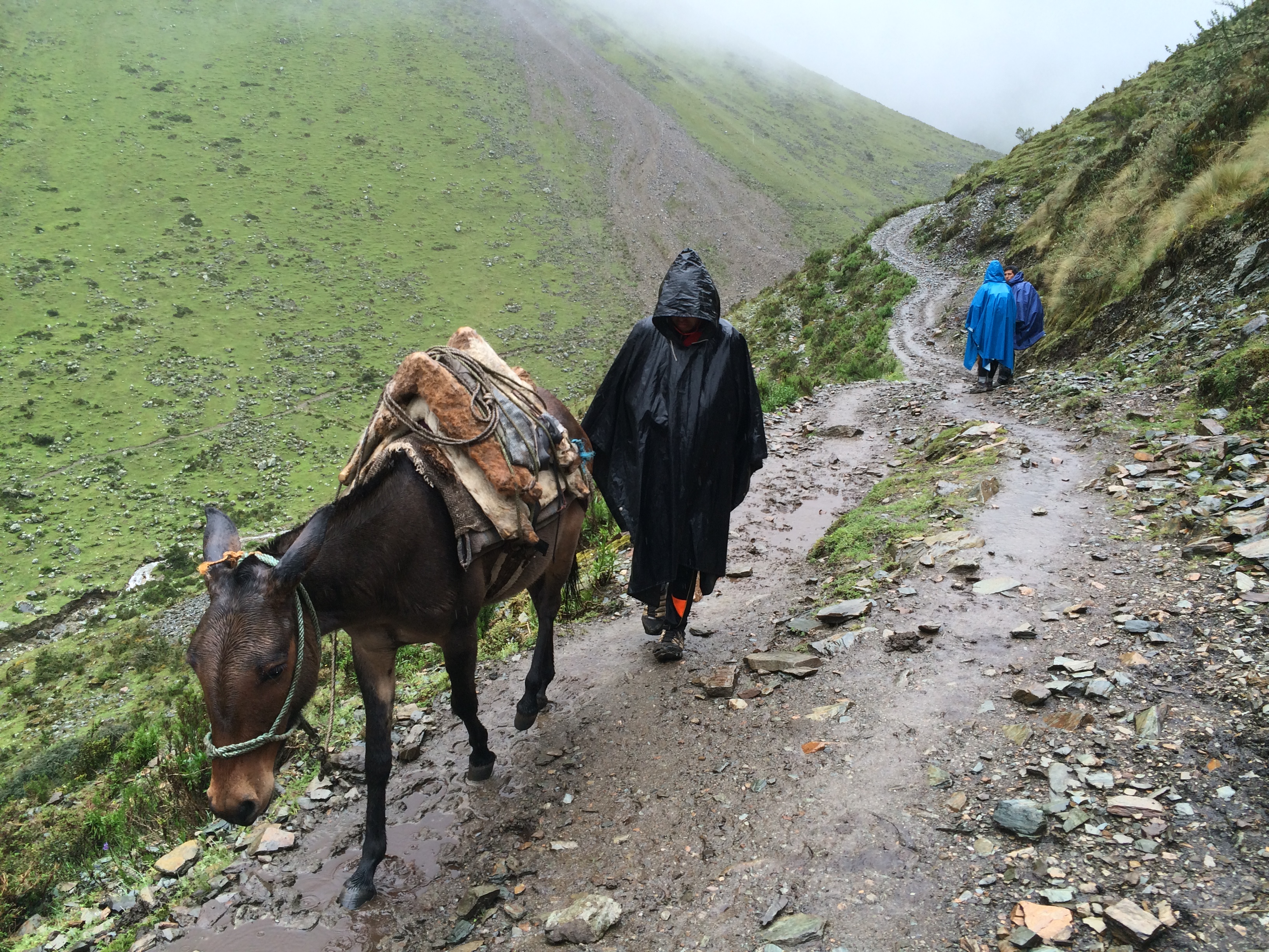
We unloaded our day packs and gave our main backpacks to the sherpa who had two horses, food and camping supplies with two chefs. Accompanied by my two daughters and these guys, this would be our crew for the next few days.
DSC_0607
IMG_7638
The men left with the horses and supplies and we went on a different path, step by step, until they disappeared into the middle of the mountain range. Almost immediately after beginning the trek, the views were stunning.
IMG_7716 IMG_7720 IMG_7719 IMG_7717
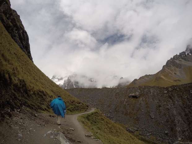
One hour after we started, we had to wear our ponchos because the rain started picking up. The landscape changed drastically basically every hour. Sometimes we walked on small rocks, then a mossy kind of swamp, then firm ground, then loose gravel and so on. However, it was almost all uphill. We enjoyed every bit of it and hours went by very quick.
DSC_0616 IMG_7653 IMG_7663
DSC_0642
By noon, I started to feel some pain on the back of my neck, and it increased by the minute. Then I felt my stomach being upset and then sinuses hit too. I was in total discomfort and has multiple bad feelings at the same time. I was out of breath and getting very tired, caused by the altitude.
By 1:00PM we reached the first camp were tends were assembled and the chefs had cooked our lunch, but I was so sick I could not enjoy like I should. Ericka and Ashley were ok, but I had to have some oxygen before I started eating. The meal was amazing with three courses. I ate just a little and was sorry for not have finished the entire plate, but none I could do that moment.

DCIM100GOPROGOPR0464.

IMG_7710
It was rainy and freezing in the high mountains, and the only comfort we had were the rhythmic steps climbing higher up the mountain. After lunch we started climbing the hardest part of the hike. We were 4,610 meters above sea level and the hike was brutal. Ashley was doing all right with our guide Antonio, Ericka was pale, but walking behind them, and I was in completely pain, dragging my feet, way back in line. I stopped every 7 or 10 meters, and simply could not walk! It took forever to beat this hour and a half climb and I think I stopped about 25 times during this stretch.

DCIM100GOPROGOPR0478.

I remember looking to my daughters and asking them all the time if they were ok. They always said yes and we kept walking and walking. Finally we reached the top and I felt a great relief because not only we got it, but from that point on we would start descend for many hours.

DCIM100GOPROGOPR0470.

I want to thank Antonio for the great moral support he gave me, because even though my steps were like of 100 year old man, he always said I was doing good and to kept going, and that I would be fine. It was true, and I did it!
The descent was good and I was feeling much better. It felt better also, because my muscles didn’t hurt anymore.
The landscape also changed a lot by the hour and we noticed the kind of tropical vegetation started to show up. The lower I got, the more familiar it became to us.
IMG_7747
IMG_7740 2IMG_7707 2
After many hours walking, my stomach started acting weird again and I did not wait a minute. I threw up, and instantaneously felt better.The night was approaching and we needed to walk a little faster to reach the camping base, and just before night, we stumbled safely into camp, running on pure adrenaline.
 DCIM100GOPROGOPR0457.
It was a beautiful plain with high mountains topped with snow all around us. The melted snow would form little creeks that came down from everywhere, creating a amazing sound of running water. It was paradise on Earth!
DSC_0641 DSC_0650 2 DSC_0653 2 DSC_0642 DSC_0643
The place had two houses apart from each other’s some animals, and a structure for camping with two bathrooms with a bowl and cold water shower.
Our tents were assembled and the chefs were preparing our dinner. I slept for about 15 or 20 minutes and joined them on a main tent. Rain came down hard, and we had some hot coffee, water crackers with butter, popcorn and hot chocolate.  We feel so good.
IMG_7757
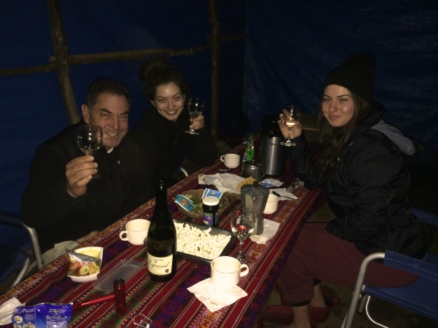
We talked for about one hour while the rain was coming hard producing a very nice sound to our ears. The dinner came after the coffee and again, the chefs did not disappoint us, the plates were well done and elaborated with elegance. It was delicious and beautiful. After this delicious meal, we stopped fro a moment to pray and cheer the moment, it was New Year’s Eve and we celebrated the date with a bottle a champagne opened by our guide and friend Antonio. Antonio expressed gratitude towards pachamama, the mother earth goddess of the Andes, and we all poured our first sip of champagne on the Earth. The moment was serene and very moving, and I thanked God, the universe and life for being alive and enjoying so much. Life is too short for not to be lived well.
After that long day, excellent dinner, I crashed on my tent and slept tight until 6AM with rain on us all night. My tent was placed between two creeks and sometimes I thought water was approaching it, but it was only my impression. Despite that, it was extremely humbling to sleep amongst the grand mountains and the sound of a roaring creek in a small tent.
The next day came quick, and I was I brand new man! It was the first day of the year, and I definitely felt revived. I woke up earlier than everybody and opened the tent to a new sunny day.
I was in shocked to see the exuberance of the nature and beauty of the valley. It was interesting to compare the scene from the previous night, due to my perspective changing from my energy. Mount Salkantay was right there, almost in front of us with it’s 6,235 meters high! It was fantastic!
DSC_0649 2 DSC_0650 2
DSC_0628 2
The photos themselves show the incredible sensation we had of being inside the movie Lord of the Rings.
DCIM100GOPROGOPR0483.DCIM100GOPROGOPR0473.
I walked all around the camp and tried taking some photos at different angles, while enjoying the morning dew and first sun rays. Later it became cloudy, but still beautiful.
 IMG_7797
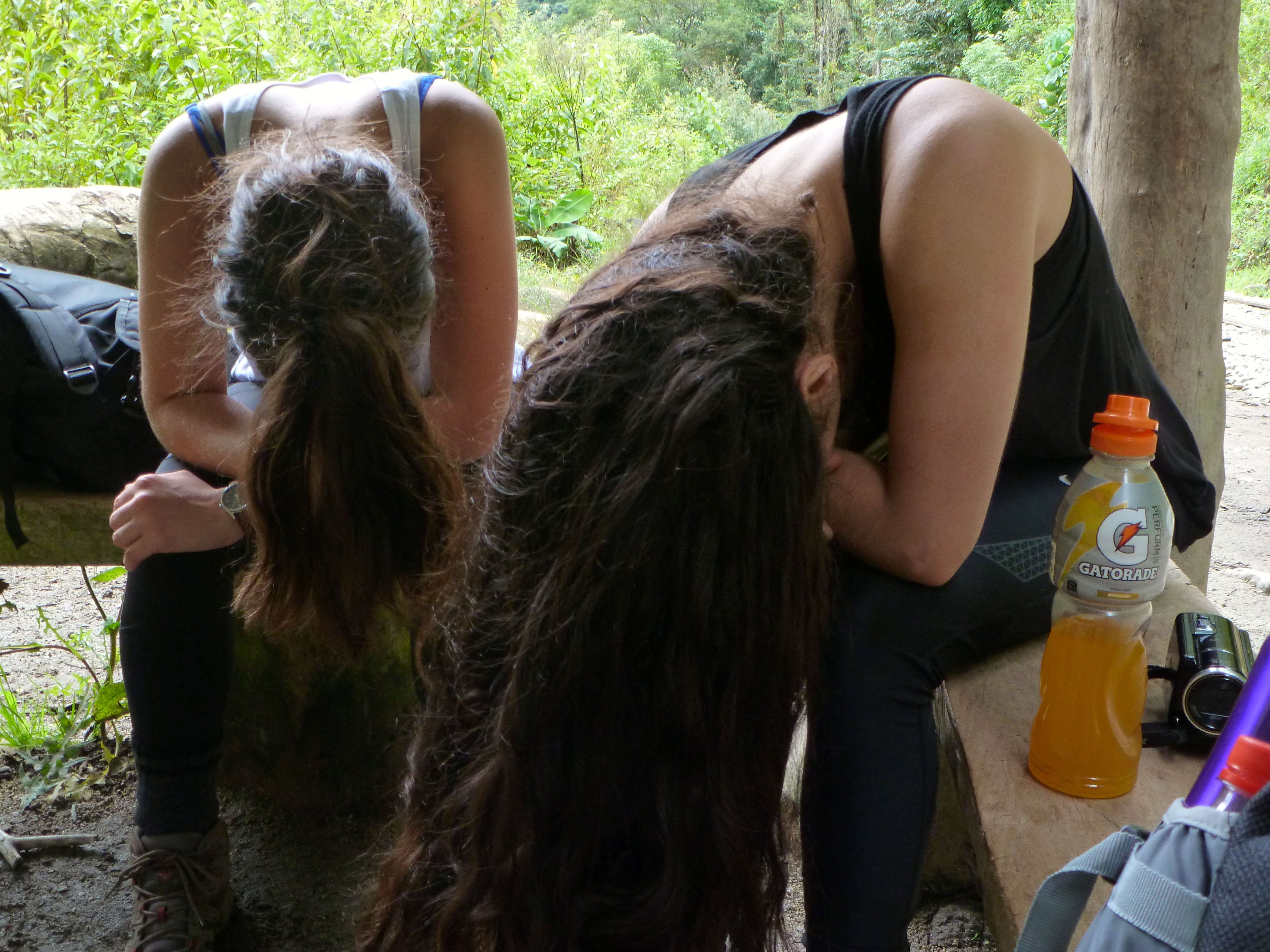
The girls woke up with a smile in their face, and we all brushed our teeth, washing our faces with ice cold water and heading back to the tents for breakfast.
IMG_7856IMG_7861
With our stomachs full, we started our downhill hike alongside loud raging rapids with crystal clear water from melted snow from the mountains.
IMG_7848
IMG_7906
We descended all day, and after 5 or 6 hours, my legs started hurting some, but we proceeded always going down and enjoying the beautiful landscape, which was very different from a day ago.
IMG_7895
IMG_7964
The river next to us grew immensely, and so did the loud sound of the rapids.
 IMG_8007
We ended up on some kind of ranch with chickens, cows and horses. We walked across a black mud track, entered the property and waited for our guides.
This property was the final point of this stretch, and we said farewell to our sherpa and his horse. A 4×4 jeep picked us and drove for 2 hours to a village called Santa Teresa, were we met a coffee grower and his family.
The dirt road that lead to Santa Teresa was extremely narrow and dangerous with a huge cliff on the side, and the 4×4 drove right on the very edge of the cliff, giving us a bad sensation and fear. Luckily we made it safe and enjoyed a quick lecture about coffee and how the community works together.
We first-handedly learned about the different coffee plants, as well as plantains and avocados. Ericka picked an avocado high in the tree, and we moved on to further observe the coffee process. We had a chance to roast and grind the coffee beans, and enjoy the freshest peruvian coffee with cake offered by the home owners. We ended up buying two bags of coffee from them, and I gave one to a friend in the city of Jasper, in Alabama. (They are coffee lovers and I hope they enjoyed it!)
IMG_8019
Our lunch was also served in this house, and from there we went on to a final destination of the day, a camp site at thermal water pools, Aguas Termales.
There were three pools with round rocks on the bottom that massaged our feet as we relaxed our muscles in the super hot waters. There were four water pipes carrying water to a drop where we could sit and have all that water on our backs! That was priceless! Next to that, there was freshly cold water from the water falls and it was amazing to chill your bones with the cold water before ultimate relaxation in the hot water.
 IMG_8034 IMG_8048
IMG_8038
Our tents were near the pools, and at night we had a wonderful dinner with Peruvian wine.
IMG_8060
The next morning we woke up early and went straight to the pool to have a relaxed massage in hot waters. We met some locals and a special little boy who did the same track we did. He was with his father who is a guide, and our guide, Antonio’s, friend. It was amazing to meet this beautiful boy full of energy on the same journey as us.
IMG_8096

DCIM100GOPROGOPR0526.

IMG_8078IMG_8091
Ericka woke up feeling sick, and threw up a couple of times that morning, but still wanted to keep going. We left by car to a place called Hidroeletrica, where is the starting point for most back packers to reach Machu Picchu.
The road was interesting with huge cliffs as usual, but we were more used to them now, and one hour later we disembarked in Hidroeletrica.
IMG_8126IMG_8102
Our track in this third day was very easy. We walked 11 kilometer on a train track until we reach Aguas Calientes, the village right below the ruins of the ancient city of Macchu Picchu.
P1100893 P1100950 P1100943 P1100917
P1100862
P1100900 P1100855
The hike was very nice, but at this point Ericka and Ashley had upset stomachs, which made their day miserable. I was very sorry about them and sometimes very worried, but we all made it safe by the end of the day.
P1100919
P1100897 P1100927
P1100890P1100888P1100875DCIM100GOPROGOPR0530.
P1100960
AGUAS CALIENTES
We arrived late afternoon at a hotel booked through the tour. This was our first day with a warm water shower in a week. The river that cross the village was furious with high fast rapids and mud color waters.
 P1100966
The village is only reachable by train or hiking, of course, and downtown looks like a train station with bars, stores, hotels and restaurants.
 IMG_8182  IMG_8164 IMG_8168 IMG_8171 IMG_8142 IMG_8146
Our hotel was right up there, on the train platform, next to a beautiful fine restaurant. After a hot shower, we all came down and enjoyed a delicious dinner and a warm rice pudding as a desert.
IMG_8190 IMG_8196
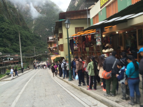
Next morning we woke up at 5am, had breakfast and left the hotel at 5:45 to be in line for the buses that would take us to the top of mountain where Maccu Picchu is located.
IMG_8208
The line was immense at that time, and I imagined people started coming as early as 4 O’clock. Our package for this tour had the tickets for the ruins included, so we just hopped on the bus when our turn came.
A twisted road took us all the way to the entrance of Macchu Picchu, and as soon as we had the first glimpse of it, we were astonished! How wonderful! How magnificent! It is a wonder of the human race! Amazing and awesome in every way!
IMG_8435
IMG_8357
We walked pretty much every where, exploring every corner, every stone, every structure. It was simply fantastic!
DSC_0825 DSC_0827 DSC_0794 DSC_0813
DSC_0721 DSC_0769
DSC_0863 DSC_0912
IMG_8412 IMG_8375
IMG_8411DSC_0884
We spent all day going up and down the stairways, alleyways and pathways, so we knew pretty much every thing except the two peaks, on on the left and one on the right side of the city.
DSC_0782
DSC_0792 DSC_0798 DSC_0843 DSC_0785 DSC_0849 DSC_0837
Those peaks were very high and required not only a person in good shape, but extra time to climb hundreds and hundreds of steep steps all away to the top. I will definitely will do it on my next visit to this wonderful place.
 DSC_0764 DSC_0817

DCIM100GOPROGOPR0601.

DCIM100GOPROGOPR0585.

DSC_0735 DSC_0824 DSC_0842 DSC_0847 DSC_0853 DSC_0874 DSC_0911 DSC_0908

At the end of the day we hopped on a train with panoramic ceiling and traveled maybe 2 hours to a city that our van was waiting for us. From there we travelled another 4 hours until Cusco, where we only arrived at night.

DCIM100GOPROGOPR0610.

IMG_8542
CUSCO
Again in the city we had been a week ago, we started exploring the alleyways of downtown where you can find interesting cafés, restaurants, churches and nice handicraft stores.
 IMG_8621 IMG_8585 IMG_8618
IMG_8556 IMG_7593 IMG_7595
We ate at fine restaurants and in particular one hamburger place called Papachos. The owner of this restaurant is the famous Peruvian chef Gaston Acurio, and we had the privilege of tasting some of his creations.
 IMG_8648 IMG_8643
One funny thing happened in Cusco. The girls and I decided to have a massage to help our sore hiking muscles, so we went to this place near Plaza de las Armas, and laid down on the beds. We waited one hour up there and I ended up sleeping, and when the massage started, we noticed they had no clue what they were doing. It was horrible and funny at the same time. When we left, we joked about the owner going out on the streets and getting random people to help, which ended up taking an hour. Reality is; they probably did not have a professional working that day and there were three of us, so they had to find just about anybody to perform the massage. Hilarious!
IMG_8663
On the last day in Cusco, we took Ashley to the airport so she could go back to the U.S. And return to work, and after a sad farewell, me and Ericka went straight to the bus terminal and got a bus to Puno, to visit Lake Titicaca.
IMG_8667 IMG_8670 IMG_8669
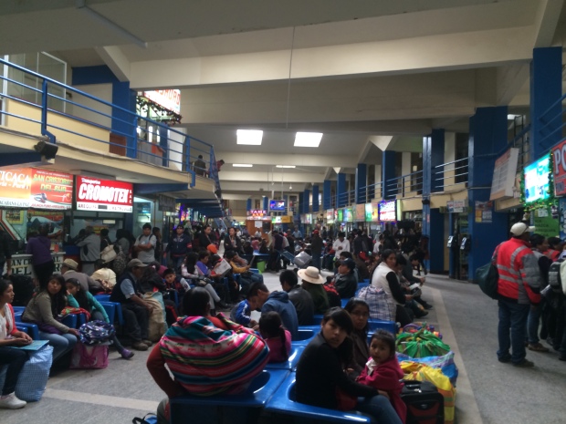
Spending time in the Cusco bus terminal was absolutely horrible. The terminal was overcrowded and disorganized, with no infrastructure for the amount of people traveling.
IMG_7583

Lima and Huacachina

On Christmas Day 2014, my 19 year old daughter, Ericka, and I began a backpacking trip across South America. Starting in Lima, Peru, we had an idea of the route that would take us through Peru, Bolivia, Chile, Argentina, Paraguay and Brazil. We flew from Miami to Lima on LAN Airlines, in my opinion, one of the very best around. The service was top notch, with abundant food and drinks, incomparable to any typical airlines in America.

THE ARRIVAL- Christmas Day – 9PM
The city is vibrant with hundreds of people everywhere on busy, loud, and happy streets, a very different scene from quiet Alabama where we left 12 hours ago. We stayed in a nearby hotel in San Isidro, the financial district of Lima,  because we would pick up my other daughter, Ashley, at the airport the next morning. After getting Ashley, we headed to Barrio Miraflores, a neighboring town of San Isidro.

IMG_7191

1508193_1050848404932515_439110106367294881_n

Miraflores is a beautiful district by the ocean with well maintained streets, lots of flowers everywhere, good restaurants and bars, interesting night clubs and a great number of crafts stores. The name Miraflores translates to “see flowers,” appropriately describing the copious amounts of flora around the district.
We spent all day walking through these streets, tasting good ceviche and sipping on Pisco sours, the national drink of Peru. At sunset, we made our way to the cliffs with a great view of the ocean, where lots of other tourists enjoyed the afternoon.

Peru is famous for it’s exceptional cuisine and the most famous chefs are international celebrities. One of the most known chefs is Gaston Acurio, who is the owner of several restaurants in Lima and other cities. One of the restaurants is a hamburger paradise called Pappachos, which we ate at in Cusco, later described in the blog. Since our hotel was located in the heart of the city, we walked to practically everywhere and saw many interesting places, including coffee and cacao shops that were stunning!


P1100805

IMG_7180

P1100772

IMG_7204

IMG_7205

DCIM100GOPROGOPR0083.

P1100799

IMG_7209IMG_7211 IMG_7253

P1100785

DCIM100GOPROGOPR0082.IMG_7231


The next morning we hScreen Shot 2015-04-13 at 4.20.17 PMeaded to the Cruz del Sur bus terminal to catch a 5 hour bus ride to Ica.  The visuals drastically changed to dark brown landscapes, followed by a more picturesque desert road scene. We arrived in the small town of Ica. This city has approximately 1 million inhabitants and lies in the middle of the desert, near another famous town, Nasca. After checking into our quaint hostel, we took a cab to the famous oasis settled between huge sand dunes and palm trees, where we walked barefoot and stretched our muscles in the warm sun.

Huacachina is a true oasis surrounded by hundreds of high sand dunes and palm trees. There are small bars and restaurants that serve decent food (including the famous ceviche) and some standard handicraft stores where we can find beautiful colorful articles made by local Indians. One of the most popular tourist attractions is a riding a big bore V8 4×4 dune buggy through the sand dunes. This heavily modified and man made buggy uses old American engines from Mustangs, Oldsmobile, Chevrolet and other brands available on the market. The ride is scary but surprisingly nice with a spectacular view of the high dunes and the oasis from a different angle. We really enjoyed it and would do it again.DSC_0375

DSC_0350

DSC_0417DSC_0402

DSC_0339

DSC_0346 DSC_0354 DSC_0419

DSC_0427DSC_0375

DCIM100GOPROGOPR0140.

DSC_0392 IMG_7291

DSC_0403 DSC_0422 DSC_0432 DSC_0397 IMG_7265DSC_0429

As the sun began to set, we walked to a nearby restaurant, enjoying pisco sours, fresh juices, and excellent ceviche.

IMG_7314


DCIM100GOPROGOPR0314.


GUATEMALA

09.20.14

Já havia pisado em solo Guatemalteco uma vez quando atravessei a fronteira a pé vindo de Belize. Naquela viagem eu estava embrenhado na mata para conhecer as pirâmides de Xanantunich e Caracol no Belize, e como estava muito próximo da fronteira, pedi para o motorista que me acompanhava para me levar até a divisa. O motorista não tinha visto de entrada e combinamos que ele esperasse algumas horas enquanto eu pudesse tentar conhecer alguma coisa na primeira cidade do país. O visto custou $50 dólares e entrei a pé através de uma ponte sob um rio bonito com águas claras.Parecia a Cidade Del Este no Paraguay, só que nos anos 80 quando ainda era Presidiente Stroessner. Ruas empoeiradas, ambulantes por toda parte e muita carga para ser atravessada de país para o outro. Visitei um restaurante e passei algumas horas perambulando pelo centro comercial, e a noitinha regressei ao Belize, reencontrando com meu motorista para me levar a Belize City, umas 3 horas dali. Sabia que a cidade de Flores estava próxima, mas na época não tinha ideia de como era esta pequena e bonita cidade que seria o portal para conhecer as ruínas de Tikal, que falarei mais adiante.

Saí de Atlanta, na Geórgia e o voo levou três horas e meia, passando por cima do Alabama, do Rio Mississipi e seu delta, o  lago Pontchartrain e New Orleans. Sempre que viajo á algum lugar diferente, gosto de ficar com o rosto colado na janelinha do avião, onde as vezes vejo cenas inusitadas e ultra interessantes. Após atravessar o  Mar do Caribe, pude observar a cidade de Merida no México, e depois de uma hora de voo sobre centenas de montanhas, aterrizamos na Cidade da Guatemala.

384964_243208292409954_309435088_n

387467_243208382409945_324380766_n

391009_243208445743272_1559168007_n

388290_243209365743180_1158268142_n

Bacana ter visto este imponente rio a 12 mil metros de altura, pois foi possível observar par

te seu trajeto sinuoso com suas margens claras das areias que o acompanham até o delta onde a gás águas barrentas misturam se com a azul turquesa do Mar do Caribe.

Lembro de um voo que fiz de Tel Aviv para New Jersey, e durante esta viagem ví claramente quando sobrevoamos a Itália onde pude observar parte do formato da famosa “bota”. Fiquei encantado com esta visão que parecia mais uma ilusão, mas não era. Quarenta minutos depois foi a vez da cidade de Barcelona na Espanha. Dava para ver o reflexo do sol nos vidros dos carros, as vias expressas, praias etc…e repito isto a 36 mil pés de altura, ou seja mais ou menos 12 mil metros.

GUATEMALA CITY

Aeroporto bonito e moderno, e o que me chamou mais a atenção foi a quantidade de pequenas lojas de duty Free, acho que eram umas doze ou treze ao todo. Até hoje me arrependo de não ter comprado um relógio Citizen Eco Drive por pouco mais de $200 dólares…já era!

O tempo estava perfeito, com 23 graus Celcius e 78% de humidade relativa ao ar, simplesmente uma delícia. O moeda da Guatemala chama se Ketzales e vale 6 por $1 dólar. Me hospedei em um hotel charmoso de duas estrelas, perto do centro, e após um banho bem quente, saí para uma caminhada na caída da noite de Sexta Feira. Caminhei uns quinze minutos e cheguei a Zona Viva, um complexo de bares, restaurantes e casa noturnas onde se concentra a maior parte das pessoas que buscam diversão, música e comida boa.

383630_243208772409906_330131269_n (1)

RUA

Achei um barzinho super legal e com gente pra lá de bonita! Fiquei realmente elétrico ao ver o que estava vendo, e logo me enturmei fazendo amizade com o bar man,  e depois algumas pessoas mais. Depois de alguns drinks, geralmente fico meio que de bobeira, meio que viajando no lugar, nas ideias, no ambiente, na música, e é claro nas pessoas. A felicidade é incrível, e é nestas exatas horas que sinto uma explosão de euforia, bem estar e orgulho de estar fazendo algo que sempre sonhei desde menino com poucos recursos, quando ainda vivia no bairro de Camilopolis em Santo André, SP.

O som deste ar era de primeiríssima qualidade, e as músicas, todas em Espanhol é claro, pareciam com nossas bandas como o Ira, Legião, Titãs, Capital etc…Como disse, as pessoas eram muito bonitas e elegante, e só para lembra, eu estava na Guatemala! Que noite, que noite!!

Procurei não beber muito e me hidratei com bastante água mineral e água de coco, até porque tinha que aproveitar o dia seguinte para conhecer novos lugares. Cheguei no hotel de madrugada e de manhã já estava de pé para o farto café da manhã.

Saí para caminhar pelas largas ruas repletas de árvores frondosas, o que lembrava os bairros nobres de São Paulo. Olha só, lugar legal, lojas de grifes, prédios modernos, hotéis de três, quatro e cinco estrelas, povo educado etc… Mas uma coisinha me perturbava a mente, quase todas pessoas que tive contacto me diziam  para ficar esperto com assaltos repentinos por motoqueiros, que geralmente levam teus pertences em segundos, chato não?
Depois de tantos alertas, parei de andar a pé a noite, carregava pouco dinheiro na carteira e andava sem relógio, mas felizmente meu bom anjo da guarda me protegeu e tudo correu maravilhosamente bem até o final da viagem.

No terceiro dia peguei um avião pequeno e parti para uma charmosa cidade a leste do país chamada Flores, onde dali iria conhecer as ruínas de Tikal.
O voo atrasou 6 horas e quase morri de fome no aeroporto, mas eles serviram uns hambúrgueres do Burger King lá pelas tantas,o que deu para suportar o tédio e barriga vazia. Voo rápido, cheguei a Flores depois da meia noite. Cidade quente tipo litoral de SP. Como não tinha reserva de hotel, pedi ao taxista que me levasse para um perto, e acabei dividindo a corrida com outro turista do Canada, e também acabamos ficando no mesmo hotel.

387754_243232779074172_14077890_n 374251_243232709074179_1935525976_n
O aeroporto de Flores não é mais que uma pista de pouso ao lado de uma avenida, e só acende a luzes quando um avião se aproxima para pousar. O trajeto desta pista de pouso ao hotel foi de exatamente cinco minutos. Na frente deste hotel havia uma casa com um quintal grande de terra e uma enorme árvore no meio, e neste local também funcionava um bar com música. Naquela noite havia uns bebuns tomando, conversando alto e alguns jogando cartas, e decidi tomar umas cervejas antes de dormir.
Meu novo amigo, o Sr Ted também topou e lá fomos. Depois de umas três cervejas geladas e duas doses de rum, fomos dormir para acordar as 5 da manhã e sair as 5:30 para as ruínas de Tikal. (Havíamos combinado com o taxista de nos levar até lá e passar o dia conosco)

Sono breve, 5 da manhã em pé, banho frio e vamos que vamos! O que acho interessante é a mudança climática de um país para o outro. Sai dos Estados Unidos no Outono, com as folhas meio secas e coloridas, brisa fresca e noites um pouquinho frias, aí chego na Cidade da Guatemala com 27 graus, e depois em Flores com 35! A manhã estava linda, com um pouco neblina e fumaça dos fogões a lenha das humildes casas ao longo da estrada com sua verde floresta tropical, que sensação boa! Paramos em uma casinha a beira estrada e tomamos alguns cafés bem forte e depois seguimos até Tikal.
Para ser sincero, me sentia na Ilha da Magia, ou seja, Florianópolis. Tudo lembrava Floripa, e como amo aquele lugar que é muito especial para mim, estava praticamente em casa.

TIKAL

Tikal foi uns dos maiores centros populacionais e culturais da civilização Maia desde o século IV antes de Cristo, mas que vemos hoje provem do período clássico, ocorrido entre 200 d.c. E 850 d.c.
Depois deste período, nenhum outro grande monumento foi construído e sua população iniciou um processo gradual de declínio, até seu abandono total por volta do século X depois de Cristo.

309728_243233535740763_54053856_nBLOG

321132_243231622407621_26110590_n 391026_243231442407639_1722833476_n 313205_243232375740879_873812430_n

ARV

O nome Tikal quer dizer “Lugar de Vozes” e estudiosos estimam que, no seu auge, a cidade teria população entre 100.000 e 200.000 habitantes.

Ao entrar na densa floresta, dados de cara com ruínas escondidas e encobertas pela vegetação, raízes e morros de terra, mas há uma grande parte já escavada por arqueologos, e esta parte sim podemos ver 100 por cento.

Estava em companhia do Sr. Ted, mas tenho meu próprio jeito de ser, logo nós separamos porque gosto de observar cada detalhe, cada pedra, cada desenho, cada rampa, túnel, passagem etc… gosto de ver realmente os detalhes, e fico só imaginando como viveram aquelas pessoas que ali habitaram. O que fariam? Como era a sociedade deles? Havia escola? O que comiam? De que trabalhavam? E o saneamento básico, higiene, como seria? Qual seria a diversão? São tantas perguntas, mas é muito difícil ter todas respostas…

A entrada do Parque Nacional Yaxhá é tranquilo após passar pela guarita de soldados do exército, paramos o carro e saímos para caminhar na floresta ultra fechada. A primeira vista são as pequenas edificações semi cobertas pela vegetação que tomou conta de tudo. Pode se observar pequenos morros que na verdade são pequenas estruturas coberta por terra e árvores.

387216_243231359074314_120552937_n 387941_243231502407633_2009302145_n

Fiquei por ali umas duas horas, caminhando, observando, admirando, fotografando e filmando inúmeros detalhes que me deixava absolutamente estonteado. O Sr Ted andava por outros caminhos e de vez em quando me dava uns gritos para tentar me mostrar algo super interessante, e lá ia eu a seu encontro. Ele foi uma pessoa bem legal e boa companhia, e como disse, cada um tinha um jeito de andar e apreciar as coisas, e sendo assim tudo foi muito tranquilo.

381763_243231855740931_2024359532_n 382606_243231972407586_495527302_n 321227_243232185740898_106541658_n 383874_243231562407627_1569529725_n390341_243231265740990_564007622_n

Além do complexo de Tikal, há muitas outras pirâmides e ruínas de cidades como Yaxhá, Nakum, Ceibal, Aguateca, San Bartolo, El Mirador e a grande Petén. Todos estes lugares espetaculares são de uma beleza invejável com cores verdes brilhante, águas azuis, fauna e flora riquissímas e um a excelente oportunidade para se fazer eco-turismo.

LAGO ATITLÁN E CHICHICASTENANGO

Depois de ter visitado vasta,ente grande parte de complexão de Tikal, o lago Petén Itza e a bonita cidade chamada Flôres, regressei a Guatemala City onde passei mais uma dia antes de nova expedição, desta vez o famoso lago Atitlán com seus imponentes três vulcões ao lado da pequena cidade chamada Chichicastenango.

374207_243234892407294_105671669_n

Contratei uma mini van para me levar até lá, uma viagem gostosa por estradas sinuosas no semi árido Guatemaltéco. Foram 6 horas de muito prazer com visuais espetaculares onde tive a oportunidade de observar inúmeras pessoas de várias tribos e etnias com suas vestimentas coloridas e muito, muito interessante. As pessoas no geral são de estatura baixa, as mulheres vestem vestidos feitos por elas mesmos, e tem cores vibrantes com desenhos aleatórios formando uma verdadeira obra de arte. Os homens são baixos também, é claro, e usam ternos com chapéu, uma beleza só!

A última parte da viagem foi meio assustadora porque descemos uma serra muito íngreme até chegar em Chichicastenango, uma cidade repleta de gente, lojas, pousadas, pequenos restaurantes e muitos vendedores ambulante. Havia muitos mochileiros também,o que dá um certo ar de segurança, pois está tribo de viajantes internacional sempre escolhe destinos seguros e bacanas.

Em pouco mais de 2 horas circulei por ruas e vielas, sempre admirando as pinturas e outras peças de artesanato local, até que fui conhecer o lago Atitlán.

387773_243232519074198_327745057_n

382949_243232579074192_19804926_n

As águas são claras, limpas e transparentes, em um lado da margem há vários restaurantes que servem frutos do mar e deliciosos peixes assados. No lado oposto há três enormes vulcões, um do lado do outro, E chamam se; Atitlán, Tolimán e San Pedro. Escolhi um desse restaurantes de frente para os vulcões e passei algumas horas deliciando um peixe frito com arroz, fritas e salada acompanhado de uma cerveja bem gelada e uma cachaça deles, o famoso aguardiente. Uma delícia!

393411_243234735740643_1132298721_n

377403_243232562407527_1694247421_n

390215_243234632407320_2133629308_n

A tardinha peguei um barco e fui até uma das ilhas que abriga o vulcão Tolimán.
Em uma possível nova viagem a este lugar gostaria de ficar neste lugar uns três dias e explorar todos os três vulcões, pois acho que seria bem legal. A próxima parada foi a cidade colonial chamada Antigua.

309722_243235205740596_1915600824_n

391998_243234819073968_938774003_n

ANTIGUA

Esta linda cidade colonial fica perto de Guatemala City e tem aos seus pés o enorme vulcão da Água com 3766 metros de altura. Antigua foi o antigo Reino Guatemaltéco e recentemente foi tombada pela UNESCO como Patrimônio Histórico da Humanidade.
Andei muito por inúmeras ruas e vielas e fiquei absolutamente encantado com praças cheias de gente, crianças brincando, vendedores pipoca, de algodão dôce, maçã do amor e outras “cositas mas”. Há várias cantinas que me pareceram muito agradáveis e definitivamente merecem ser visitadas em uma próxima viagem.

386438_243235255740591_318049003_n 390994_243235699073880_1404414735_n 390320_243235459073904_1011584292_n

Ao oeste de Antigua há mais dois vulcões imponentes, o Vulcão do Fogo com 3763 metros e o Acatenango com 3976 metros de altura.

392878_243235525740564_1033411181_n

377196_243234579073992_1922200752_n

Deixo a Guatemala com um sorriso no rosto e uma excelente impressão deste lindo país na América Central. Até breve, Antigua, até breve Guatemala.

LÉON, NICARAGUA

Desde que visitei a Nicarágua em 2012, a vontade de voltar era grande, e desta vez visitei a cidade Colonial de Léon, a segunda maior depois da capital do país, Managua.
León está situada a 96 km a noroeste de Managua e 18 km do Oceano Pacífico, e tem menos de 400 mil habitantes. Cidade charmosa com casas coloridas, León é o ponto de partida para conhecer vários vulcões, fazer trilhas, e até pegar altas ondas no Oceano Pacífico. Como já havia dito no outro blog, a Nicarágua possui 19 vulcões, sendo 8 ativos (Cosi Guina, Momotombe, Cerro Negro, San Cristóban, Las Pilas, Massaia, Concepción e Telica).
Nesta viagem escalei três deles, o Cerro Negro com 728 metros de altitude, Momotombe com 1297 metros, e o Telica com 1061 metros.
Como sempre, gosto de viajar nas primeira horas do dia, e desta vez embarquei as 6 da manhã de Birmingham, Alabama para Miami e depois um voo direto para Managua.
Um probleminha de distração e perdi meu voo em Miami, aí tive que embarcar em um outro bem mais tarde. Cheguei em Managua a noite, e como seria complicado para ir até a rodoviária, decidi tomar um taxi até Léon. Paguei 70 dólares e a viagem durou 1 hora e 20 minutos.
leon
A pousada que escolhi chamava se Colibri e era bem simples porém efetiva. Reservei um quarto só para mim porque ronco bastante e também gosto de minha privacidade. Os banheiros eram fora e não havia ar condicionado, o que tirei de letra, até porque o ar condicionado da parte superior de minha casa havia quebrado uma semana antes e resolvi não conserta lo para poder me acostumar com o calor. Deu certo.
hostelhotstal
Dormi a primeira noite tranquilo e pela manhã tomei várias xícaras de café na ampla mesa do saguão principal. Ali me debrucei nos mapas para conhecer a região para ver as melhores opções de trilhas e escaladas de vulcões. Escolhi o Cerro Negro com 728 metros de altitude, fácil de subir, e ainda com o bônus de descer um lado dele com uma prancha de madeira, podendo alcançar até 70 km por hora.
map
CERRO NEGRO;
cerro1
Paguei $35.00 dólares e me juntei com várias outras pessoas em um micro ônibus que nos levou até o parque nacional. A viagem levou 1 hora e meia e foi tranquila. Entre esta pessoas que também iriam subir, havia um grupo de quinze meninas e dois rapazes, e eles vinham de várias partes do mundo para uma aventura espetacular. Eles compraram um pacote de 18 dias pelo site gaventures.com. Eles começaram a viagem na Península de Yucatán, no México, e sempre por terra foram visitar os sítios arqueológicos de Xanantunich no Belize, Tikal, na Guatemala, Copan em Honduras, e agora estavam na Nicarágua onde iriam conhecer vários lugares como a cidade colonial de Granada, o vulcão Massaya entre outros lugares interessantes. No Belize, eles pegaram um barco e foram até Cayo Caulker, uma ilhota espetacular onde pode se mergulhar ou fazer snorkel em lindos corais, incluindo o famoso Buraco Azul (Blue Hole) Coincidência ou não, eu já havia visitado exatamente todos os lugares que eles foram, sem exceção. Só com uma diferença, levei cinco anos em varias viagens com um custo relativamente alto, e eles fizeram em pouco mas de duas semanas, pagando apenas $2.700,00 dólares mais os atrativos a parte. Um excelente preço.
cr
cweroo5
Cerro Negro é um vulcão jovem e apareceu em Abril de 1850, e por ser tão recente, tem apenas 728 metros de altitude. A subida foi relativamente fácil porque o terreno é rochoso e dá apoio aos pés. O visual é impressionante e fica cada vez mais interessante na medida que subimos. Fiquei um tempão observando as belezas naturais em todas as direções, e notei que o solo é bem quente devido ao calor da lava que rola embaixo da gente.
ceroo2cerroceroo3
O instrutor nos deu umas dicas para descer deslizando com a prancha, e depois de umas cinco pessoas, lá fui eu. O segredo é freiar com os pés até um certo ponto, porque depois da metade do trajeto a prancha pega muita velocidade. Há vários casos de acidentes, e alguns com muita gravidade. Respeito é bom e conserva os dentes, portanto nada de bancar o herói aqui.
ceroo5
cer1484
Minha descida foi rápida e meu tênis novinho foi para o brejo, pois gastou o solado de uma forma surpreendente. Foi nos dado um macacão e um par de óculos tipo de mergulhador, mas eles estavam tão riscados que resolvi usar os meus óculos escuros mesmo. Conclusão, ví com clareza mas as pedrinhas que bateram no meu rosto e cabelo acabaram deixando um monte de marquinhas nas lentes.
cerrrrr
ceroo7
Minha dica para quem vai descer o Cerro Negro; há pranchas estilo snow board para quem tem bastante experiência, e as pranchas normais que usei que é para ir sentado. Use botas com meias 3/4 porque meu tênis gastou e deformou a sola, sem falar que encheu de pedrinhas durante a descida. Não use óculos escuros caros porque as pedrinhas irão riscar los. Se puder, leve um par de luvas baratas, tipo estas que vendem em postos de gasolina ou loja de materiais de construção. Não leve equipamento de fotografia ou filmagem, a não ser uma Go Pro, que por sinal é bem útil. Evitem levar mochila porque para descer a gente tem que inclinar o corpo para trás e carregar a mochila na barriga,o que não é nada legal. Leve 3 ou 4 garrafinhas de água, tomem café pela manhã e podem levar alguma fruta tipo manga, banana ou maçã. Boa descida!
Cheguei na cidade com uma baita de uma fome, comi um prato de espaguete alho e óleo com um filé de frango. Tomei um suco de manga e uma cerveja. Depois de um banho de água fria (morna), deitei com um ventilador na cara e dormi umas duas horas.
A noite já estava descansado, saí para caminhar na cidade e depois jantar em um dos inúmeros restaurantes bacanas que há em León. Desta vez tomei uns wiskies, cerveja e comi arroz com feijão misturado, salada e um bife na chapa. Muito bom.
Terceiro dia:
MOMOTOMBE;
momo1
Acordei as 5 da manhã, tomei aquele banho gostoso direto do cano sem eletricidade, fiz uns alongamentos e parti para encontrar o pessoal que me levaria para outro vulcão, o Momotombe.
Por sorte havia um grupo de surfistas da França que haviam alugado uma pick up Toyota 4×4, e aceitaram me levar com eles. Só paguei os $35.00 da agência.
Paramos em um posto de gasolina, comprei bastante água, 1 litro de leite, Red Bull e bolachas. O trajeto até o local de subida levou 1 hora e meia e fui atrás da caminhonete. Tomei até café enquanto estava lá atrás curtindo a brisa matinal e observando a bela paisagem Nicaragüense.
momo6momo5
Já dentro do parque nacional, o trajeto ficou bem difícil e suei para me equilibrar na caçamba da pick up porque havia muitas raízes e enormes crateras em um terreno super íngreme. Paramos em um determinado local e começamos a longa caminhada para atingir o cume do vulcão.
momo9
Logo nos primeiros 4 minutos de subida minhas pernas deram sinal de dor, e foi assim o tempo todo, e houve vários momentos que simplesmente não aguentava mais.
DSC_0001 DSC_0004 DSC_0026
momo7
O terreno mudava a cada 30 minutos de subida, ora era rochoso, ora arenoso, ora com vegetação rasteira e assim por diante. Quanto mais subia, mais difícil ficava, mas em contrapartida, a cada parada para um breve descanso, podia deliciar com a beleza impressionante do horizonte, onde podia avistar montanhas menores, o lago Managua e vários povoados da região.
momo11momo10
Nesta jornada procurei esquecer meu trabalho, minhas obrigações e minha casa, mas lembrava das minhas filhas e de minhas motos que havia deixado na garagem, mas ali era exatamente onde queria estar.
O ar era puro e agradável, mas a subida continuava a ser penosa a ponto de passar pela minha cabeça se realmente conseguiria chegar no cume. Os Franceses, três rapazes e uma moça, me humilharam de tanta forma física. Eles sumiam na minha frente o tempo todo. Eu os alcançava nas paradas, e com uma cara meio sem graça respondia sua perguntas e dizia estava tudo bem. Eles me perguntaram umas oito vezes, sempre preocupados com minha integridade e capacidade de subir com eles.
momo4
Os últimos 30 metros para chegar no topo foram os mais difíceis, pois tínhamos que usar as mãos para se apoiar, mas as pedras eram soltas, e a cada passo dolorido dado para frente, a gente voltava dois para trás , era desesperador…Minha única esperança era quando olhava para cima e via os Franceses lá no alto, e aí pensava, se eles conseguiram, eu também iria conseguir!
momo000 momomooo
Após passar por dificuldades incríveis, chegamos no cume, a cratera era enorme e o fortíssimo vapor de dióxido de enxofre não permitia que respirássemos com normalidade. Os olhos e a garganta ardiam muito e só podemos desfrutar da beleza daquele lugar único por alguns poucos minutos. Tiramos fotos, olhamos para todas as direções e iniciamos a descida.
momo2
momo3momo8
Até para descer foi complicado, porque agora as pernas doíam ainda mais para segurar o corpo!  O trajeto de subida levou 3 horas e meia e para descer levamos 1 hora e meia. Fiquei acabado, mas feliz.
moom13
Cheguei ao Hostel detonado e cabisbaixo, só queria um banho e cama. Quando abri o cano para tomar o banho, surpresa, haviam cortado a água para reparo na tubulação da rua! Esperei uma hora, mas estava agoniado, então comprei 4 garrafas de 2 litros de água e tomei um banho delicioso com somente 2 garrafas. Dormi 1 horinha e saí a noite para jantar. Mal conseguia caminhar de tanta dor nas pernas…
Quarto dia:
Acordei meio dolorido, fiz alguns alongamentos, tomei meu banho frio, café e já estava pronto para mais uma aventura, a de subir o vulcão Telica com 1061 metros de altitude.
Este tour sai a tarde para poder ver as lavas com as cores laranja bem vivo, e a volta e feita com lanternas, já a noite. O tour começa as 2 da tarde e a gente volta as 9 da noite. Aproveitei a manhã para ir até a praia Las Peñitas, que fica a 18 kms de distância de León.
Peguei um taxi e me custou 9 dólares e levou 20 minutos. Um ônibus custa menos de 1 dólar, mas eu não tinha tempo de esperar o horário dele.
LAS PEÑITAS;
pen pen2 pen3penn
Uma praia bacana com areia escura e altas ondas, onde surfistas de várias partes do mundo se encontram, inclusive Brasileiros.
O local é bem deserto e passei a manhã toda nas águas mornas do Oceano Pacífico, e foi ótimo para aliviar as dores da escalada do dia anterior.
Tomei duas cervejas e comi um delicioso ceviche misto com frutos do mar e peixe.
Como não havia taxi ou ônibus para voltar para León, conversei com alguns moradores e consegui uma cara que me levasse de moto por $ 10 dólares. Bacana, cheguei a tempo para mais um banho e algumas frutas. Me apressei caminhando algumas quadras para encontrar com o grupo que iria subir o Telica.
TELICA;
tel11
Este é relativamente fácil comparado com o Momotombe, mas não tão fácil assim.
As trilhas iniciais são parecidas com as trilhas que estamos acostumados no Brasil. Sobe se um pouco, caminha se reto um pouco, desce um pouco e assim vai. Há muitas árvores ao redor para se apoiar e o piso é firme. A trilha é mista que dá até para descansar as pernas quando depois de uma subida íngreme, a gente caminha um pouco em um plano mais nivelado, oque alivia as dores nas pernas. O calor era forte com 37 graus e 98% de humidade relativa do ar, deixando a gente ensopado de suor. Para complicar um pouco começou a chover, e aí sim nós nos molhamos por inteiro. Após 40 minutos de caminhada, paramos debaixo de uma frondosa mangueira carregada de frutas verdes e maduras. Nosso guia subiu na árvore, apanhou várias mangas e jogou para todos nós que aguardávamos abaixo como crianças esperando doçes.
tel1410660198_748040021926776_7398811837747712797_n
Seguimos pelas trilhas e quanto mais subíamos mais o tempo piorava, ameaçando chover. Como disse, as trilhas eram similares as que conhecemos no Brasil.
trail
A última parte que leva a cratera, a vegetação é rasteira e não há mais árvores. Um frio com uma neblina molhada tomou conta da montanha e agora, depois de suado, molhado da chuva e com muito calor, passamos a sentir frio!
tel3
tel
tel2
A chegada na boca da cratera foi emocionante, mas a neblina cobria todo o visual.
Ficamos ali mais ou menos uma hora e por sorte a neblina sumia por alguns segundos, permitindo a gente de ver a lava rolando lá embaixo, incrível.
tel10
tel7
tel8
tel9tel16
telica
Ah, o barulho deste vulcão é igual a de uma turbina gigante! É pura energia do vapor de dióxido de enxofre que deixa qualquer um emocionado.
Está escalada começou a tarde para que a gente pudesse ver a lava no escuro, tornando assim mais interessante, e a descida seria com lanternas.
Depois de ver esta maravilha da natureza em ação, iniciamos a descida com lanternas nas escuras trilhas que nos levaria até o carro de apoio que irei nos esperar. Logo que escureceu mesmo, caiu uma tempestade com raios e trovões assustadores, A cena era surreal, raios clareavam tudo, e os trovões eram ensurdecedores. Nossas lanternas iluminavam só onde dávamos  os passos, e ninguém conversava uma palavra. Acho que todos estavam tensos, bem pelo menos eu estava!
Após 2 horas e 20 minutos chegamos na Land Rover que nos aguardava. A chuva caia bem forte e os raios amedrontavam, e quando fomos sair com o carro, o alternador pifou, deixando nos na escuridão! Tivemos que abrir duas janelas e colocar as lanternas para fora até poder alcançar a estrada, e de lá foi mais fácil, mas mesmo assim continuávamos com as lanternas coladas no pára-brisa e no vidro de trás por segurança.
A noite a tempestade aumentou, e ainda assim fui jantar em um restaurante chamado Aíyoy, que servem comidas deliciosas. Convidei meu guia e seu ajudante, e lá trocamos bastante ideias. Tomamos o famoso rum Flor de Caña, envelhecido em barril de carvalho por 18 anos, e cerveja Toña. Comi camarão e carne e fui dormir como um anjo.
Na manhã seguinte peguei uma van até a capital Managua que levou 1 hora e meia.
Já no terminal rodoviário, peguei um taxi por 20 dólares até o aeroporto. Se quisesse pegaria um ônibus por $1 dólar, mas queria garantir meu voo e fui de taxi mesmo. A van de León para Managua custa $3 dólares.
E assim termina esta bela viagem a um país que é um espetáculo com suas belezas naturais impressionante. Na minha próxima viagem a Nicarágua, irei para uma ilha chamada Ometepe que fica no lago Cocibolca.
Uma dica para quem quer ver um vídeo de um ciclista tentando descer o Cerro Negro. Procurem no Youtube algo com bicicleta no Cerro Negro. Divirtam se é até o próximo blog.